 he
first thing every school child learns about the town is that the name is
Spanish for "butterfly." Consequently, butterflies take center stage is Mariposa from business decorations to an annual Butterfly Days Festival!
he
first thing every school child learns about the town is that the name is
Spanish for "butterfly." Consequently, butterflies take center stage is Mariposa from business decorations to an annual Butterfly Days Festival!
 alifornia
originally was peopled by Native American tribes and those indigenous to
the Mariposa Area are Miwoks. But, the first Europeans to explore
the land came from the Spanish colony of Mexico. Those first explorers
discovered a creek meandering through a gentle valley and all around it
swarmed butterflies. That intrepid explorer named the place "Arroyo
de las Mariposas" which roughly translated means stream of butterflies.
Eventually, after a couple of incarnations, the name of Mariposa stuck.
alifornia
originally was peopled by Native American tribes and those indigenous to
the Mariposa Area are Miwoks. But, the first Europeans to explore
the land came from the Spanish colony of Mexico. Those first explorers
discovered a creek meandering through a gentle valley and all around it
swarmed butterflies. That intrepid explorer named the place "Arroyo
de las Mariposas" which roughly translated means stream of butterflies.
Eventually, after a couple of incarnations, the name of Mariposa stuck.

 ariposa
lies in the foothills of the Sierra Nevada Mountain range in California
at approximately the 2000 foot elevation (1,953 feet according to the sign
as you enter the town) and town enjoys a modest population of about 1,769
people. (That figure is, of course, for the town itself and not the
outlying areas.) The town of Mariposa is the County Seat of Mariposa
County and all of the local and most of the state and federal government
offices are located there.
ariposa
lies in the foothills of the Sierra Nevada Mountain range in California
at approximately the 2000 foot elevation (1,953 feet according to the sign
as you enter the town) and town enjoys a modest population of about 1,769
people. (That figure is, of course, for the town itself and not the
outlying areas.) The town of Mariposa is the County Seat of Mariposa
County and all of the local and most of the state and federal government
offices are located there.
 ccess
to the town is easily attained via Highways 49 and 140. Highway 140
(known as the all-season highway because it remains open all year) continues
on up to Yosemite National Park. The ride along Highway 140 is, itself,
a marvel as travelers rapidly ascend from the agricultural lands of the
San Joaquin Valley, through foothills and, finally, follow the "Wild and
Scenic" Merced River through a spectacular canyon.
ccess
to the town is easily attained via Highways 49 and 140. Highway 140
(known as the all-season highway because it remains open all year) continues
on up to Yosemite National Park. The ride along Highway 140 is, itself,
a marvel as travelers rapidly ascend from the agricultural lands of the
San Joaquin Valley, through foothills and, finally, follow the "Wild and
Scenic" Merced River through a spectacular canyon.
hough
logging once flourished as an industry in Mariposa County, its prime industries
now are tourism and agriculture.

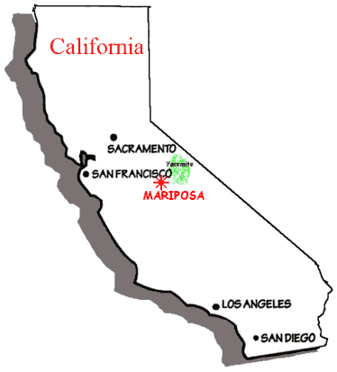
ariposa
is situated roughly in the center of California and is the southern link
of the "gold chain" (the name given to the series of foothill towns that
experienced the goldrush of the 1800's).
 t
lies approximately 40 miles (depending on who you ask) south-west of Yosemite
National Park.
t
lies approximately 40 miles (depending on who you ask) south-west of Yosemite
National Park.
For trivia fans, the distance (roughly) between Mariposa and:
Boise, Idaho is 637 miles (1,025 km)
Las Vegas, Nevada is 466 miles (750 km)
Los Angeles, California is 288 miles (463 km)
New York City, New York is 2,876 mile (4,628 km)
Oakland, California is 160 miles (257 km)
Phoenix, Arizona is 652 miles (1,049 km)
Portland, Oregon is 740 miles (1,191 km)
Sacramento, California is 157 miles (253 km)
San Diego, California is 411 miles (661 km)
San Francisco, California is 170 miles (274 km)
Seattle, Washington is 916 miles (1,474 km)
Vancouver, B.C. is 1,059 miles (1,704 km)
and
Washington D.C. is 2,318 miles (3,731 km)
For those who want to find the distances between other places try MapQuest

he summers in Mariposa are usually warm and dry with an average mean summer temperature of 94 o - 96 o in the town area.
 inters in Mariposa are cool and wet, but severe weather is unusual. The average
mean winter temperature in the town area is 32o, while, the average seasonal rainfall is 20-25 inches. Snow at this elevation
averages 1-5 inches (enough to make the kids happy - but not so much to
make the parents unhappy!).
inters in Mariposa are cool and wet, but severe weather is unusual. The average
mean winter temperature in the town area is 32o, while, the average seasonal rainfall is 20-25 inches. Snow at this elevation
averages 1-5 inches (enough to make the kids happy - but not so much to
make the parents unhappy!).
Here's a look at the current weather:
